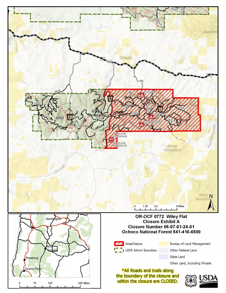
The Ochoco National Forest, in coordination with the Prineville District Bureau of Land Management (BLM), Crook County Sheriff’s Office, and fire management officials, has implemented an emergency closure for the east side of the Maury Mountains due to ongoing wildfire activity. These closures, along with those enacted on nearby BLM-managed lands, are necessary to protect public safety and to ensure that firefighters can safely carry out suppression efforts. Evacuation orders are currently in place for parts of Crook County.
These closures are essential for ensuring public safety and enabling firefighters to operate without obstruction. Heavy equipment, including bulldozers and water tenders, must access narrow, hazardous roads, while aerial resources such as helicopters and air tankers are conducting operations. Unauthorized individuals in the area increase the risk of accidents and interfere with firefighting activities. Additionally, erratic fire behavior, falling trees, and debris further heighten the danger.
We acknowledge that these closures affect the public, especially hunters and other recreationists who frequent the Maury Mountains during this season. This decision was not made lightly but is necessary to safeguard both the public and firefighting personnel.
We appreciate the public’s understanding and cooperation during this time. The closure will remain in place until conditions improve, and it is deemed safe to lift restrictions.
For detailed maps and additional information regarding these closures, visit the Ochoco National Forest website and the BLM website.
Evacuations:
Evacuations have been issued for areas from SE Pine Creek Road (FS RD 17) east to SE Camp Creek Road, extending south from Paulina Highway to the southernmost portion of SE Camp Creek Road, including SE Tackman Road and Antelope Reservoir. Additionally, Level 2 “Be Set” evacuations are in effect from SE Camp Creek Road east to the South Fork Crooked River, from Paulina Highway south to approximately GI Ranch Road. For the latest information please visit the Crook County Sheriff’s Facebook and webpage.
Visit the official source for wildfire information in Central Oregon at centraloregonfire.org for wildfire updates or follow fire information on X/Twitter @CentralORfire. Call 9-1-1 to report a wildfire.


