
The Deschutes County Sheriff’s Office is supporting firefighters responding to or engaged with new fires. Two areas are under evacuation notices. The Backside Fire located west of Mt. Bachelor in the roadless area has necessitated Level 3 (Go Now) Evacuation notices for the Mt Bachelor area including Mt. Bachelor, Todd Creek Horse Camp, Sparks Lake, Devils Lake, and Quinn Meadow area.
Updated September 7, 2024/ 6 PM: Due to the Firestone Fire, the Deschutes County Sheriff’s Office has expanded evacuation notices to the north. Level 3 (Go Now) Evacuations include all areas north of the Lake/Deschutes County Line to Pine Mountain, east of FS 18 (China Hat Rd) and FS 25 (Spencer Wells Rd), west of Moffit Rd.
Level 3 (Go Now) Evacuations near Mt. Bachelor due to the Backside Fire remain in effect.
Level 3: Means “GO” evacuate now. Leave immediately! Danger to your area is current or imminent, and you should evacuate immediately. If you choose to ignore this advisement, you must understand that emergency services may not be available to assist you further. DO NOT delay leaving to gather any belongings or make efforts to protect your home. This will be the last notice you receive.
Current Level 1 (Be Ready)
The Firestone Fire located south of Pine Mountain near the Lake County line necessitated a Level 2 (Be Set) Evacuation area for the area south of Pine Mountain between FS 18 (China Hat Rd) and FS 23 (Sand Springs Rd). Due to the Firestone Fire, the Deschutes County Sheriff’s Office has issued Level 1 (Be Ready) Evacuations include areas north of Pine Mountain between FS 25 (Spencer Wells Rd) and Moffit Rd all the way to Hwy 20.
Due to an incident near Flat Top Butte in Northern Lake County, the Deschutes County Sheriff’s Office is issuing Level 1 (Be Ready) for areas west of FS 18 (China Hat Rd), north of the Deschutes County/Lake County Line, south of FS 21 Rd, and generally southeast of Newberry Caldera.
Level 1: Means “BE READY“ for potential evacuation. Residents should be aware of the danger that exists in their area, monitor emergency services websites and local media outlets for information. This is the time for preparation and precautionary movements of persons with special needs, mobile property and (under certain circumstances) pets and livestock. If conditions worsen, emergency services personnel may contact you via an emergency notification system.
Current maps including evacuation areas can be found at:
https://deschutes.org/
For fire information, you can visit the Central Oregon Fire Information site at: www.centraloregonfire.org
**End of Update**
The Deschutes County Sheriff’s Office is supporting firefighters responding to or engaged with new fires. Two areas are under evacuation notices.
The Backside Fire located west of Mt. Bachelor in the roadless area has necessitated Level 3 (Go Now) Evacuation notices for the Mt Bachelor area including Mt. Bachelor, Todd Creek Horse Camp, Sparks Lake, Devils Lake, and Quinn Meadow area.
Level 3: Means “GO” evacuate now. Leave immediately! Danger to your area is current or imminent, and you should evacuate immediately. If you choose to ignore this advisement, you must understand that emergency services may not be available to assist you further. DO NOT delay leaving to gather any belongings or make efforts to protect your home. This will be the last notice you receive.
The Firestone Fire located south of Pine Mountain near the Lake County line necessitated a Level 2 (Be Set) Evacuation area for the area south of Pine Mountain between FS 18 (China Hat Rd) and FS 23 (Sand Springs Rd).
Level 2: Means “BE SET” to evacuate. You must prepare to leave at a moment’s notice. This level indicates there is significant danger to your area, and residents should either voluntary relocate to a shelter or with family and friends outside of the affected area, or if choosing to remain, to be ready to evacuate at a moment’s notice. Residents MAY have time to gather necessary items, but doing so is at their own risk. This may be the only notice you receive. Emergency services cannot guarantee that they will be able to notify you if conditions rapidly deteriorate. Area media services will be asked to broadcast periodic updates.
##
Effective immediately, the Deschutes National Forest is temporarily closing two areas on the Bend-Fort Rock Ranger District due to the Backside and Firestone Fires.
Backside Fire | Temporary Emergency Fire Closure
An emergency closure order for the Backside Fire burning one mile west of Mt. Bachelor and 16 miles west of Bend is now in effect.
Campground reservations for developed campgrounds listed below are being cancelled starting today through the next week.
The following developed recreation sites are temporarily closed:
- Edison SnoPark
- Edison Shelter
- AC/DC Shelter
- Sheridan Shelter
- Quinn Meadow Trailhead
- Quinn Meadow Horse Camp
- Devil’s Lake Camp
- Devil’s Lake Trailhead
- Soda Creek Campground
- Sparks Lake Picnic Area
- Ray Atkeson Trailhead
- Todd Creek Horse Camp
- Todd Creek Trailhead
- Mount Bachelor
Roads in the area:
- All National Forest System Roads found within the area closure are closed. Cascade Lakes Highway (NFSR 46) and River-Summit Drive (NFSR 45) will remain open for public use.
Firestone Fire | Temporary Emergency Fire Closure
An emergency closure for the Firestone Fire burning 26 miles east of La Pine is now in effect. Please see attached map and closure order for details. Closed developed recreation sites and roads include:
The following developed recreation sites are temporarily closed:
- NFSR 25 OHV Trailhead (RD 25 Trailhead)
- NFSR 2510 OHV Trailhead (Rd 2510 Trailhead)
- Camp 11 OHV Trailhead
- Groundhog OHV Trailhead
- China Hat Campground
- South Lava OHV Trailhead
- South Ice Cave Picnic Area
Roads in the area:
- All National Forest System Roads found within the area closure are closed.
- NFSR 23 will remain open for public use. NFSR 22 west of the closure boundary will remain open for public use.
- NFSR 18 north and south of the closure boundary will remain open for public use.
For information regarding temporary emergency closures on the Deschutes National Forest visit fs.usda.gov/alerts/deschutes/alerts-notices.
##
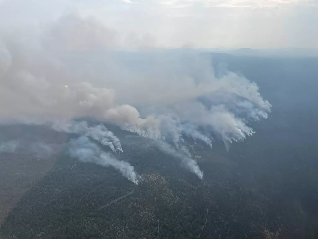
Central Oregon received multiple lightning strikes from several storm systems over the last 24 hours. Very light precipitation accompanied those systems. Today, firefighters on the Bend-Fort Rock Ranger District of the Deschutes National Forest responded to approximately 15 wildfires ranging in initial report size from a quarter of an acre to 150 acres. Fires were predominately clustered near the Mt. Bachelor Roadless Area and the eastern edge of Flat Top Butte and East Butte. These wind-driven fires grew at a rapid rate of spread throughout the day resulting in very large acreage increases. The largest fires today include:
Firestone Fire – 3000+ acres, located SE of Newberry Caldera on the Deschutes National Forest, and burning in brush and timber. Multiple air and ground resources are responding. A Complex Incident Management Team (CIMT) has been ordered.
Backside Fire – 80 acres, located west of Mt. Bachelor on the Deschutes National Forest. Multiple air and ground resources are responding.
Evacuations
Level 3 (Go Now)
The Deschutes County Sheriff’s Office issued the following “The Backside Fire located west of Mt. Bachelor in the roadless area has necessitated Level 3 (Go Now) Evacuation notices for the Mt Bachelor area including Mt. Bachelor, Todd Creek Horse Camp, Sparks Lake, Devils Lake, and Quinn Meadow area. “
Level 2 (Be Set)
The Deschutes County Sheriff’s Office issued the following “The Firestone Fire located south of Pine Mountain near the Lake County line necessitated a Level 2 (Be Set) Evacuation area for the area south of Pine Mountain between FS 18 (China Hat Rd) and FS 23 (Sand Springs Rd).” For more information visit flashalert.net/id/DeschutesSO?alert=1 and stay up-to-date on Deschutes County evacuation notices using their interactive map: experience.arcgis.com/experience/6f8868c4477e462b8a653a89260268fc/page/INCIDENT(S)/#data_s=id%3AdataSource_1-Emergency_Response_OEM_Public_2766%3A187
It’s been a very busy fire year in Oregon. Wildland firefighting resources, not only in Central Oregon, but throughout the nation, are stretched thin. Weather predictions are calling for continued high temperatures, low humidities, windy conditions along with lightning storms which will lead to additional fire starts. Everyone needs to do their part to avoid additional human-caused starters. Remember, one less spark means one less fire putting our wildland firefighters and our communities at risk.
Visit the official source for wildfire information in Central Oregon at centraloregonfire.org for wildfire updates or follow fire information on X/Twitter @CentralORfire. Call 9-1-1 to report a wildfire. For smoke and air quality information visit fire.airnow.gov. ###